Use APKPure App
Get 渋滞情報マップ(交通情報,規制,通行止,高速,料金検索) old version APK for Android


Easily check the latest highway and general regulations, road closures, and traffic jam information nationwide! Search expressway tolls for up to 3 routes! Full of useful functions for driving such as live camera and Orbis!
<The ultimate real-time traffic congestion information app!>
▼Check real-time traffic congestion information for expressways and general roads nationwide!
▼Displays past, present, and future traffic information!
▼Check the local situation with live camera footage available nationwide!
▼Compare highway tolls at a glance by searching tolls for up to three routes!
■Main functions of the traffic congestion information map
●Traffic congestion map (expressway)
・Check traffic congestion information for expressways nationwide on a simple map.
・You can seamlessly free scroll through expressways nationwide.
・Traffic congestion and congestion information is displayed in color on the map.
・You can use GPS location information to display traffic congestion information for your current area.
・Displays the closest IC to your current location.
・You can switch between areas nationwide.
・[Selectable areas] Hokkaido, Tohoku, Kanto, Kanto (Shuto Expressway), Hokuriku, Tokai, Tokai (Nagoya Expressway), Koshin, Kinki, Kinki (Hanshin Expressway), Chugoku, Chugoku (Hiroshima Expressway), Shikoku, Kyushu, Kyushu (Fukuoka Expressway), Kyushu (Kitakyushu Expressway), Okinawa
・You can quickly switch between expressways and urban expressways nationwide with the touch of a button.
● General road map
・You can check traffic congestion information nationwide on the map.
・Congestion and congestion information is displayed in color on the map.
・You can display a rainfall map that shows rainfall information from 1 hour ago to 6 hours later.
● Toll search
・You can search for tolls for expressways by specifying the entrance and exit ICs.
・Route lines are displayed on the roads you pass through on the expressway map.
・Cash, ETC tolls, ETC2.0 discounts, late-night and holiday discounts, etc. are also supported.
・Date and time settings and toll categories can be changed.
● Real-time traffic congestion information from probes
*Probes are traffic information generated from GPS positioning data sent by users of our smartphone app.
●Traffic congestion forecast calendar
・You can check traffic congestion forecasts up to two months in advance in calendar format.
----The following can be used after paying to register----
●Real-time traffic congestion information from VICS
・The latest VICS data is displayed in real time.
*VICS is an information and communication system that distributes road traffic information collected, processed, and edited by the Road Traffic Information and Communication System Center, a foundation.
●Traffic congestion maps using VICS information (highway maps and general road maps)
・Traffic congestion information and regulation information such as congestion, congestion, accidents, road closures, and chain regulations are displayed in color.
<The highway map is now even more convenient to use! >
★ Traffic jam and congestion forecast information can be displayed for up to 12 hours in advance
★ Traffic jam and congestion status for the past 2 hours can be displayed on the highway map
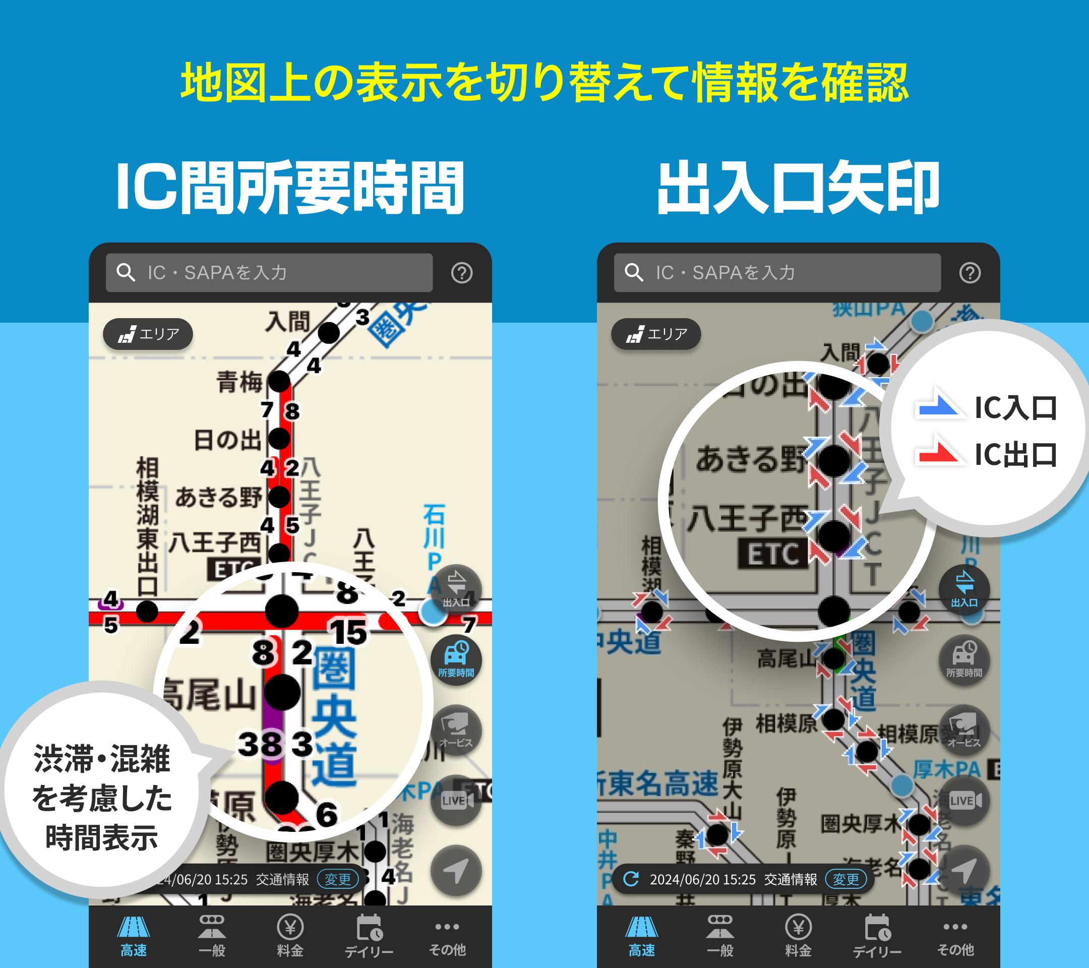
★ The time required to pass between ICs can be checked
★ The entrances and exits of the up line and the down line can be visually confirmed with arrows
★ Traffic jam distance, restrictions, and restriction period can be checked by tapping the traffic information line on the map
★ Accident restrictions and IC restriction icons are displayed, and restriction information can be checked by tapping
★ Live camera and speed camera information can be checked
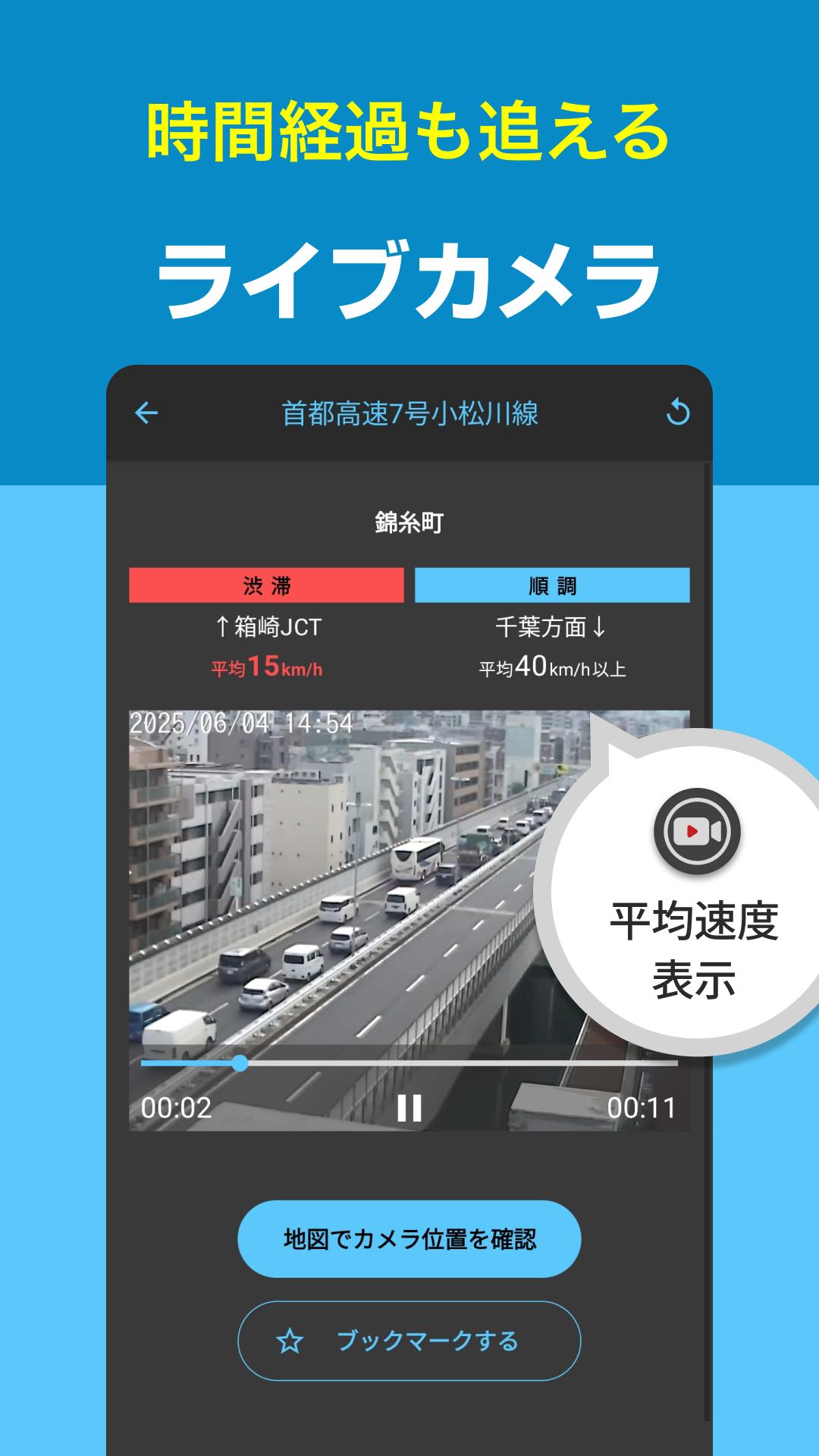
● Live camera
・ You can check the images from live cameras nationwide.
・ Road conditions such as snowfall can also be checked in real time.
● Speed camera display
・ Displays the type of speed camera and the direction of the camera on the general highway map.
● "AI traffic jam forecast" that shows how much more crowded it is than usual
・ The degree of congestion every hour is displayed in a graph, so you can intuitively check where it is more crowded than usual.
・ Like a weather forecast, the traffic jam forecast for sections where congestion is likely to occur is displayed with icons on the map.
● Display your vehicle's position (highway)
- Displays an icon showing your vehicle's position on the highway map while driving on the highway
- Follows your vehicle's movement, so you can drive while checking regulations and traffic jams.
■ Supported OS
Android 9.0 or higher
Last updated on Sep 5, 2025
Ver1.42.0(2025/9/1)
JCTを名称で検索できるようになりました。
- 高速タブ上部の検索バーから利用可能です。
Ver1.41.4(2025/8/25)
・Android15に対応しました。
・ハイウェイモード中に時刻と距離が更新されなくなる場合がある不具合を修正しました。
Ver1.41.3(2025/8/4)
軽微な不具合を修正しました。
Ver1.41.2(2025/7/17)
料金検索の結果画面で車種と支払い区分を変更して再検索できるようにしました。
軽微な不具合を修正しました。
Ver1.41.1(2025/7/2)
軽微な不具合を修正しました。
Ver1.41.0(2025/6/16)
雨雲レーダー機能をアップデートしました!
・雨雲の表示を高解像度化させ、雨雲の動きがより詳細に確認できるようになりました
・雨雲の予測時間が最大30時間先まで確認できるようになりました
Ver1.40.0(2025/5/26)
・高速地図上でICの出入り口有無が確認できるようになりました。
Latest Version
![]() 1.42.0
1.42.0
Uploaded by
พีทคนเดิม แล้วจะเป็นใคร
Requires Android
Android 9.0+
Available on
![]()
Category
Report
Discover what you want easier, faster and safer.

渋滞情報マップ(交通情報,規制,通行止,高速,料金検索)
1.42.0 by NAVITIME JAPAN CO., LTD.
Sep 5, 2025